By Jenny Schuetz, Adie Tomer, Caroline George, Joseph Kane, Julia Gill
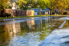
The National Oceanic and Atmospheric Administration (NOAA) maintains a website documenting climate-related disasters that cause over $1 billion in losses. The agency lists 18 such events in 2022, including droughts and wildfires in the Southwest, floods in Kentucky and Missouri, hailstorms in the Upper Midwest, hurricanes in Florida, and tornadoes in the Southeast. The message of the data is clear: All U.S. communities will face disruptions to our daily lives from climate change, but the nature, frequency, and severity of these disruptions will vary widely across places in any given year.
While individual people and communities cannot alter the course of a hurricane or alleviate drought, there are numerous ways for them to lower their exposure to climate risk or mitigate the physical and financial impacts of climate-related events. Actions such as purchasing disaster insurance and building climate-resilient infrastructure should be part of holistic strategies to protect communities. But to take these actions, residents and their local governments first need to know what the relevant risks are. For example, while coastal Floridians know they are at a higher risk of hurricanes than their inland peers, it is much harder for them to assess the relative risk of wind damage and storm surges within their specific counties or neighborhoods. It’s similarly difficult to predict localized risks from more chronic climate stresses such as sea level rise and extreme heat.
And yet, more and higher-quality, higher-resolution data is becoming available for local assessment. At the same time, predicting the impacts of climate events on communities—damages to homes, businesses, and infrastructure—is becoming an ever more important and sophisticated part of the real estate and financial services industries. But two types of consumers who would greatly benefit from local climate risk data—households and local governments—still have limited access to this information.
In this brief, we discuss how households and local governments could use local climate risk data, explore the current availability of that data, and outline several challenges facing public and private data providers.
People and municipalities can use local climate risk data to adjust how and where they build
Providing people and local policymakers with geographic climate risk data allows them to alter their investment decisions and personal behavior in a variety of ways depending on what information they are given and their preferences and access to resources.
Take people’s housing choices. In choosing where to live and how much to pay for a home, people want to know the quality of local public schools, crime rates, proximity to parks, and the quality of local transportation. How climate change affects different neighborhoods—now and in the future—should factor into housing choices as well. A recent experiment conducted by the real estate company Redfin and a team of academic researchers found that when potential homebuyers were shown online listings disclosed to have high flood risks, they shifted their search toward lower-risk properties.
Households can respond to climate disclosures like those in the Redfin study in a variety of ways. Some may choose neighborhoods at higher elevation or decide not to live in a coastal community altogether. Others might place higher value on the lifestyle benefits of being near the ocean, but choose to rent rather than purchase a home to limit their financial risk. And awareness of local climate risks isn’t just important for people in the process of relocating. Climate risks have changed and will continue to change over time; people who bought their homes 10 years ago may not have been in areas with a high flood or fire risk at the time, but now face greater risks. Being aware of changes in climate risks helps households decide whether to purchase additional insurance, install a sump pump in the basement, or invest in stronger, wind-resistant windows, to name a few adaptive strategies.
Local governments would also benefit from greater awareness of place-specific variations in climate risk. Which bus stops, homes, and public spaces face the greatest exposure to extreme heat and would benefit from cooling features such as tree canopies or green roofs? Which neighborhoods are most likely to flood during major rain events, and how can cities use rain gardens or sewer upgrades to manage the deluge? Which roadways are the least resilient to major climate events and either need to be fortified or potentially abandoned?
The current state of local climate data needs improvement
While climate risk data has long been a part of how we plan and build American communities, older information systems are no longer fit for new climate realities. As early as 2011, a landmark publication from the National Academies of Sciences, Engineering, and Medicine called attention to the need for “widely-accepted approach[es] for conducting vulnerability assessments” and describes available data as “lacking.” Ten years later, the Government Accountability Office found that the Federal Emergency Management Agency’s flood hazard maps—which inform the National Flood Insurance Program—no longer “reflect the best available climate science or include information on current flood hazards.” Notably, many properties that do not fall inside these flood hazard zones—and therefore do not carry flood insurance—experienced flooding in large storms such as Hurricane Sandy. Recent wildfires in California and Colorado also revealed how many property insurance policies were misaligned to current risks.
Now, rapid innovations in environmental monitoring and digitized parcel data are helping public agencies, businesses, nonprofits, and community-based organizations modernize climate risk data. This data makes it possible to estimate risks of flooding, drought, wildfires, extreme heat, pollution, or coastal erosion for each parcel of land—if not each 10-square-meter coordinate—in the country. Some datasets develop metrics for specific climate risks or future emissions scenarios, while others produce indexes the general public can more easily understand. For example, the Environmental Protection Agency’s interactive mapping tool allows users to see risk levels for drought, wildfire, sea level rise, and aggregate flood risk for small neighborhoods (census block groups), as well as pollution from multiple sources. This granular data complements larger-scale data, such as the Climate Impact Lab’s county-level impact maps, which our colleagues have used to assess regional vulnerabilities in the U.S.
Improved climate risk data can result in compelling use cases for private investors and policymakers, such as granularly measuring urban heat islands, outlining climate resilience strategies for subsidized housing, developing new risk ratings to fundamentally transform the National Flood Insurance Program, estimating regional economic losses in the event of natural disasters, and tracking environmental justice burdens across disadvantaged communities. The different types of metrics and the geographic scales at which they are available offer flexibility in answering different policy or research questions. For example, while insurance firms may want to know expected damages for a given property across all climate risk categories, a county parks department may be more interested in drought and heat metrics at a neighborhood scale.
Of course, producing new, high-quality data and applications is not cheap. Environmental monitoring agencies such as NOAA will need federal funding to continue investing in equipment and staff expertise. And private data providers will need access to cash flow—whether through paying customers or outside investment—to keep updating and improving their products.
What risks do new data sources present, and how will society address them?
For all the potential benefits of more granular climate data, publishing it carries some risks.
One issue is the possibility of false certainty. Even with climate models constantly improving, emerging data sources will still have wide margins of error, particularly around predicting the most uncertain climate events, such as hurricanes. Yet it’s easy to imagine some individuals treating a single data source as gospel, even though there can be significant variation among similar data products and there is limited transparency regarding underlying analytical models. Governments and industry will need to find ways to manage uncertainty with their constituents and customers.
Another concern is how data could impact equity. America’s history of redlining offers a clear example of how mapping perceived risks can lead to disinvestment and discrimination. To the extent that climate risks overlap with racial, economic, and social characteristics, vulnerable communities could face additional barriers, such as higher property insurance rates or a lack of new infrastructure in places of need. Policymakers will need to write regulations that ensure ratings agencies, insurers, government agencies, and others are not discriminating against any people or places.
The price of data could create a barrier to adoption for public agencies, nonprofit organizations, and individuals as well. Datasets that are produced and managed by federal statistical agencies such as the Census Bureau and Bureau of Labor Statistics are made publicly available at no charge to users. But data products created by private firms are typically sold to individual subscribers such as insurance companies and credit rating agencies—often for substantial fees. Financial institutions are able and willing to pay for these services to mitigate fiduciary risk associated with climate change, but most civic organizations have tighter budgets. One example of using the data for public good comes from the nonprofit Climate Central, which has used their own proprietary data to conduct groundbreaking scientific research on flood risk in order to build global citizen awareness of climate vulnerability. The country’s wealthiest cities and counties may be inclined to spend local tax dollars to buy high-quality climate data, which could lead to wiser investments in infrastructure or the ability to counter predatory real estate practices. But it could also further exacerbate capacity differences between those wealthier communities and poorer ones that can’t afford such data.
Addressing these concerns won’t be easy, and will require experimentation. Processes like the Treasury Department’s Climate Data and Analytics Hub pilot are promising efforts. Finding the right balance between transparency and equity will require cities, states, and the real estate industry to test different approaches to implementation. Adaptation strategies that work for second-home owners in Miami may not work for low-income households in Houston’s flood-prone neighborhoods, so placing diverse voices into the policy discussion is essential.